(Photos and information Hole, 2010)
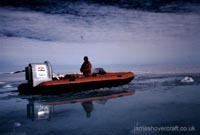
Two Tiger 4 craft on sea ice near Ridge Island (67 42°S; 67 07°W), Antarctica. Click image to enlarge.
The following incredible photographs (click to enlarge) and information has been kindly sent to me by Dr. M. J. Hole, from expeditions on the Seal Nunataks area of the (now non-existent) Larsen B ice shelf with the British Antarctic Survey in 1987-8 (Google Maps view of the area is embedded below). Statistics and a layout of the Tiger 4 craft follow the article.
This survey expedition used two Tiger 4 craft adapted from original specification for weight purposes from their original 604cc engine to a lighter 540cc Rotax air-cooled 7,000rpm direct-drive engine from skidoos. Transported individually by means of a ski-equipped DeHavilland Twin Otter aircraft (right) the craft were disassembled, loaded onto the plane and then re-built at the survey site on arrival at the ice shelf on the Weddell Sea. Between their survey site and their aircraft ski-way (no airstrip!) lay 150miles of Antarctica including a 3km high mountain range. Rescue due to breakdown of the craft could take over a month!
On the photo of the craft's engine and fan you can see a black cylinder to the left of the engine. This contraption built from a dried-milk tin, foam rubber and gaffer tape was to prevent fine powder snow blocking the carburettor intake. A cross-sectional diagram of this assembly is provided at the bottom of this page. The team also installed a patch of GRP (Glass-Reinforced Plastic) between the exhaust and the hull to stop it from burning a hole when hot.
Hovercraft were the best practical means of transportation in this Sea Nunataks area, whereas in other areas skidoos and sledges would normalls suffice. With summer temperatures mostly between -15°C and 0°C and 24-hour daylight, pools of meltwater formed over 10m deep in places on the ~100m thick ice, in and amongst areas of blue ice and snow. It is a fair conclusion that no other method of transport could cope with such variable terrain.
Typical distances travelled by skidoo and sledge in these extreme environments could be in the region of 30km per day, at a rough maximum speed of 10mph. Using a system of jerry cans and fuel dumps at set distances along a route, the range of the hovercraft used in here the Antarctic could be extended, and the survey team was able to travel about 80km in one day - unheard of in such conditions - so much so, radio reports of progress were met with skepticism!
On the occasions where the craft were to travel over loosely packed, deep soft snow ("softers"), the hovercraft lost too much lift to be able to continue on the cushion without help. In these circumstances, the team laid out two sheets of tarpaulin to hover onto, flew across them onto the furthest sheet and manually moved the first (now behind) sheet ahead of the current. This process was slow and labour intensive, but, according to Dr. Hole, it was effective.
The two Tiger 4s, hull No.'s 030 and 031 (RTK marine serial No.'s H571 and H570 respectively) still exist today, 030 is now owned by the Hovercraft Museum, the other went on to work for Hover Aid in Africa.
Statistics
| |
distance (km) |
time (hours) |
fuel consumption (litres) |
| Proving Trips |
184 |
4.75 |
83 |
| statistics |
2.2 km/l |
17.5 l/hr |
38.7 km/hr |
| Ferrying loads & laying fuel dumps |
122 |
... |
95 |
| Science journeys |
655 |
18.8 |
336 |
statistics |
1.9 km/l |
17.9 l/hr |
34.7 km/hr |
| Total distance travelled |
945 km |
|
|
| Total flight time |
26 hours |
|
|
Google Maps view of the Seal Nunatak Group area on Larsen B ice shelf, Antarctica.
14/09/14-->
-42.jpg)
-42.jpg)
-48.jpg)
-46.jpg)
-56.jpg)
-47.jpg)
-10.jpg)